|
|
|
|
Contribution on floods and droughts
Erich J. Plate
Abstract:
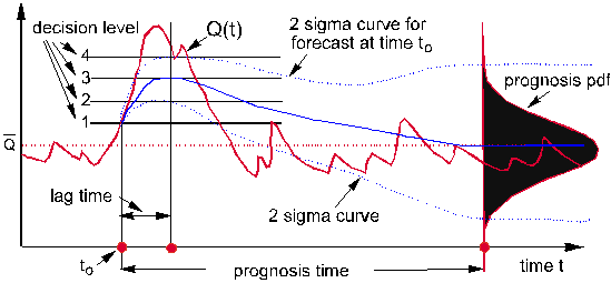 Fig. 1: Schematics of flood forecasting – with decision levels included Of critical importance is the lead time, which is the time interval between the making of a forecast of an extreme event, and the time when an extreme event occurs, as is illustrated for flood forecasting in fig. 1. In hydrology, the process of forecasting is a process of decision making under uncertainty, because of the impossibility of the exact prediction of an extreme event. This is illustrated by the error bounds indicated in fig. 1 If the lead time is too long, the forecast becomes meaningless, except as a prediction method for a rare event to be used in design of measures for protection against extreme events – building reservoirs to alleviate droughts, for example, or dikes to protect against floods. The shorter the lead time, the better the forecast, but the less time is available for action. Because floods and droughts are extreme meteorological events, a good forecast of weather extremes is a good basis. But for floods, the length of the lead time depends not only on the weather forecast, but also on the size of the catchment. The larger the catchment or basin upstream of the point of forecast, the longer the lead time becomes, so that the forecast of floods, for example on the river Rhine for the City of Cologne, can be done with a much longer lead time than the forecast for an alpine village in a small catchment basin subject to flash floods from very local thunderstorms. It is the task of scientists to devise methods of more accurate and earlier weather forecasts, better use of the weather forecast in hydrological models, and better methods of rapid communication of forecasts to decision makers. However, uncertainties can never be avoided. Therefore, an early warning system has to be based on a proper balance between the lead time and the uncertainty of the forecast. People falsely alarmed of an extreme event that did not occur will pay less attention to the next early warning. In practice, this is accomplished by a warning in stages, as is indicated for floods in fig. 1. This figure is based on the practice in Germany. The earliest warning may come from the weather service, upon which the flood forecasting group makes its first forecast. If the forecast indicates that a level of criticality might be reached, they issue a first warning. This forecast has a low accuracy and goes only to low local administrative levels, to make sure that water officials and employees are standing by. With an increase in forecasting accuracy, and with increasing certainty that a critical level will be exceeded, higher level decision makers get involved, and when an extreme threat to the population may indeed be expected, the highest ranking official of the region may be alerted to issue orders which affect the whole population, or which involves rescue and repair missions of more than a local nature. It is evident, that the last steps in the early warning chain, the disaster management strategy, is common to many types of disasters, and therefore, the local fire brigades are the natural helper in cases of flood emergencies, as well as for the case of droughts, where they have to provide the distribution system for emergency water supplies – if the water shortage ever reaches such a low level that this service is needed. It is concluded, therefore, that one of the most important lessons from the decade is that voluntary units of potential helpers are created in regions endangered by extreme natural events, and that these helpers are trained to manage all types of disaster which might occur. Hazard maps and appropriate rescue materials and equipment must become available to allow the effective training and operation of these units. |